Land Above The Trees - Rocky Mountain National Park
Colorado's Rocky Mountain National Park beckons nature lovers with wildflowers, wildlife, and unrivaled scenic beauty.|
In one of North America's great alpine strongholds, summer is a fleeting season. The 30-foot drifts that choke Trail Ridge Road, the one access across Rocky Mountain National Park, are rarely cleared by snowplows before Memorial Day. By early September, days shorten, pre-dawn temperatures dart toward freezing, and hillsides of aspen shimmer with the colors of molten gold. By mid-October, thigh-high snows prompt the closing of Trail Ridge, and for the next seven months, the park is under the icy hand of winter. So it's July and August when the park's beauty is at its wildflower best. Even then, the snow never leaves the high summits in this park that rises from 7,800 feet above sea level at the Beaver Meadows entrance west of Estes Park to 14,255 feet at the summit of Longs Peak. One-third of the park is draped in tough, ground-hugging tundra, a major reason that the area's flower-strewn valleys, cool forests, and snow-smothered mountains were set aside as a national park in 1915. With only one east-west road, your itinerary is set in advance. The toss-up is whether you approach the park from the west, keeping a lookout for mangy moose knee-high in the wetlands of the broad Kawuneeche Valley, or via the Peak-to-Peak Scenic |
 |
The latter is the most common approach, and wise visitors choose to spend at least one night in Estes Park, the closest town, so they have time to explore this dynamic landscape. Although it's possible to drive through the park on a day trip from Denver, it makes for a 10-hour day with not even a half-hour for a hike. Campgrounds are the only option for overnighting within the park: south of the park's western border, the nearest resort towns are Grand Lake and Granby.
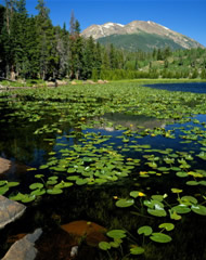
If you have two days, head for Bear Lake on the first morning. If you're not there early, you'll want to take a free shuttle bus, as parking is limited. At 9,745 feet, it's the park's only subalpine lake, with a paved road running right to the lodgepole pines rimming the shore. Crystal-clear and sapphire blue, Bear Lake is typically alpine, formed by a now-vanished glacier that dumped rock debris hundreds of feet thick all around it. Most of these rock piles (called moraines) are carpeted in green, so they appear like undulating hills.
Looking south across the lake, you'll see Longs Peak. It's not only the highest point in the park but exceeds every mountain northward in the Rockies on this side of the Yukon. The strenuous climb to the summit is not for the casual hiker.
The only gear you'll need to negotiate the many hikes that radiate from Bear Lake is a bottle of water and some sturdy shoes. A favorite route heads to Nymph Lake and beyond to Dream Lake. Choose your picnic spot to take in both Hallett Peak and Flattop Mountain. In the gorge between the two mountains, Tyndall Glacier, one of the few glaciers in the park, sparkles like a jagged diamond.
In the afternoon, take a break from hiking for horseback riding or fishing. Stables at Sprague Lake and Moraine Park offer hour or longer rides that go through meadows so broad and welcoming that early pioneers called them "parks." It's in these same valleys that elk by the hundred gather at twilight during September. While cows cluster and forage, the bulls bugle so loudly that their calls reverberate through the ponderosa pines edging Moraine and Horseshoe parks. The riding trails at this lower altitude are remarkably free of challenging ups and downs, a result of how cleanly the glaciers scoured these meadows less than 20,000 years ago.
For those who throw a line in Fall River, Mill Creek, or Glacier Creek, the catch will be one of four species of trout. They'll likely be on the small side, but small is good when it comes to straight-from-the-skillet flavor. Many streams on the western side of the park are closed to give the reintroduced greenback cutthroat trout a good start.
Early the next morning--before the traffic slows to a look-at-that-view crawl--is the best time to take on Trail Ridge, the highest continuously paved road in the United States. If you're a gawker like me who stops at every pullout and hikes the wind-buffeted Tundra Trail, the 48-mile trip from Estes to Grand Lake will take a good four hours.
The ascent begins in the breezy ponderosa woodlands near Beaver Meadows. Lime green aspen shimmer under the turquoise sky for the first few miles, but by Rainbow Curve, at 10,829 feet, only the strongest of trees like the gnarled limber pine can withstand the pummeling from year-round icy winds.
It will feel like winter when you pull out at Rock Cut at a dizzying 12,110 feet. It's at this point that you rummage in the trunk for a parka or extra sweater, turn on the heater, and ask yourself how many buffalo robes the Ute and Arapaho Indians might have worn when they traversed this trail in search of elk, bear, and deer.
Despite the persistent chill, you'll want to brave the half-hour Tundra Trail, keeping an eye out for shrill-voiced pikas, like little rabbits minus a tail, that work overtime harvesting plants for a long winter of underground dining. From trail's end, catch your breath at vistas of hard-edged mountains beheaded by massive clouds.
If you're the kind of driver, or passenger, who catches your breath when your car eases to within a few inches of a several-thousand-foot drop-off, you'll be happy to learn that your next crossing of Trail Ridge will be slightly less of a thrill. The historic retaining wall at Rock Cut, high on Trail Ridge Road at the edge of a steep cliff, has been repaired. The rock wall, which was as low as four inches--an insignificant deterrent--has been rebuilt to 27 inches. Whew.
As quickly as Trail Ridge Road climbs, it descends, corkscrewing past views of the glacier-sculpted Never Summer Mountains and slicing through lush Kawuneeche Valley. On the roller-coaster plunge down from the land of tundra, you'll shed your winter gear, roll down the windows, and remember that everywhere else in the Lower 48, except here in the land of glaciers, tundra, and surging peaks, it's still summer. Bring on the ice cream--you've left winter miles behind!
For information, call the Rocky Mountain National Park's Visitor Center Headquarters at (970) 586-1206 or check the Web site, www.nps.gov/romo. For hotel information, contact the Grand Lake Chamber of Commerce (800-531-1019) or Estes Park Resort Association (800-443-7837). Trail Ridge Road usually closes mid- to late-October through May.
COPYRIGHT 2001 World Publishing, Co. (Illinois)
COPYRIGHT 2001 Gale Group